Chapter Name: Map Reading and Interpretation
Short Questions and Answers
Question 1.
State what is indicated by the following symbols about the land use:
(a) Tanks and canals
(b) Open scrub
(c) Stony waste
(d) Causeway
Answer.
(a) Presence of tanks and canals indicates that the land is used for agriculture.
(b) Presence of open scrub indicates that the land is used for sheep and goat rearing.
(c) Presence of stony waste indicates that the land is uncultivable.
(d) Presence of causeway indicates a dry river and desert regions which receive only seasonal rainfall.
Question 2.
Where are the thickly settled areas located in a village?
Answer.
The thickly settled areas located over fertile plains and on wide river valleys.
Question 3.
What does a dendritic drainage pattern indicate about the land?
Answer.
A dendritic drainage pattern indicates that the land has soft surface rock material suitable for agriculture.
Question 4.
How can the climate of a place be inferred from the topo-sheet?
Answer.
Climate of a place can be inferred from the latitudinal extent of the area covered by the toposheet and the type of vegetation found there. For example, the climate of a place 10° N latitude will be warmer than the place at 35° N latitude.
Vegetation type also gives an indication of the climate of a place. For example, rain forests are found in the heavy rainfall areas, where the temperature is between 25°C and the average humidity exceeds 77%. Similarly, the presence of scanty growth of cactus, thorny bushes and grass suggest arid and semi-arid climate.
Question 5.
What are the factors that affect settlements in an area?
Answer
The factors that affect settlements in an area are as follows-
Physical factors:
- Body of water (transportation routes, water for drinking and farming)
- Flat land (easy to build)
- Fertile soil (for crops)
- Forests (timber and housing)influence the settlements in an area
Human factors:
- People who share a common language, religion, or culture
- Social networks or supports
- Quality of life
- Employment
Match the following.
Question 1.
| Evidence | Occupation |
|---|---|
| The settlement near the main road | Agriculture |
| Parks | Forestry |
| Coast, lakes | Cattle grazing |
| Yellow patch | Fishery |
| Meadows | Entertainment |
| Green patch | Trade |
Answer.
| Evidence | Occupation |
|---|---|
| The settlement near the main road | Trade |
| Parks | Entertainment |
| Coast, lakes | Fishery |
| Yellow patch | Agriculture |
| Meadows | Cattle grazing |
| Green patch | Forestry |
What do the following diagrams indicate?
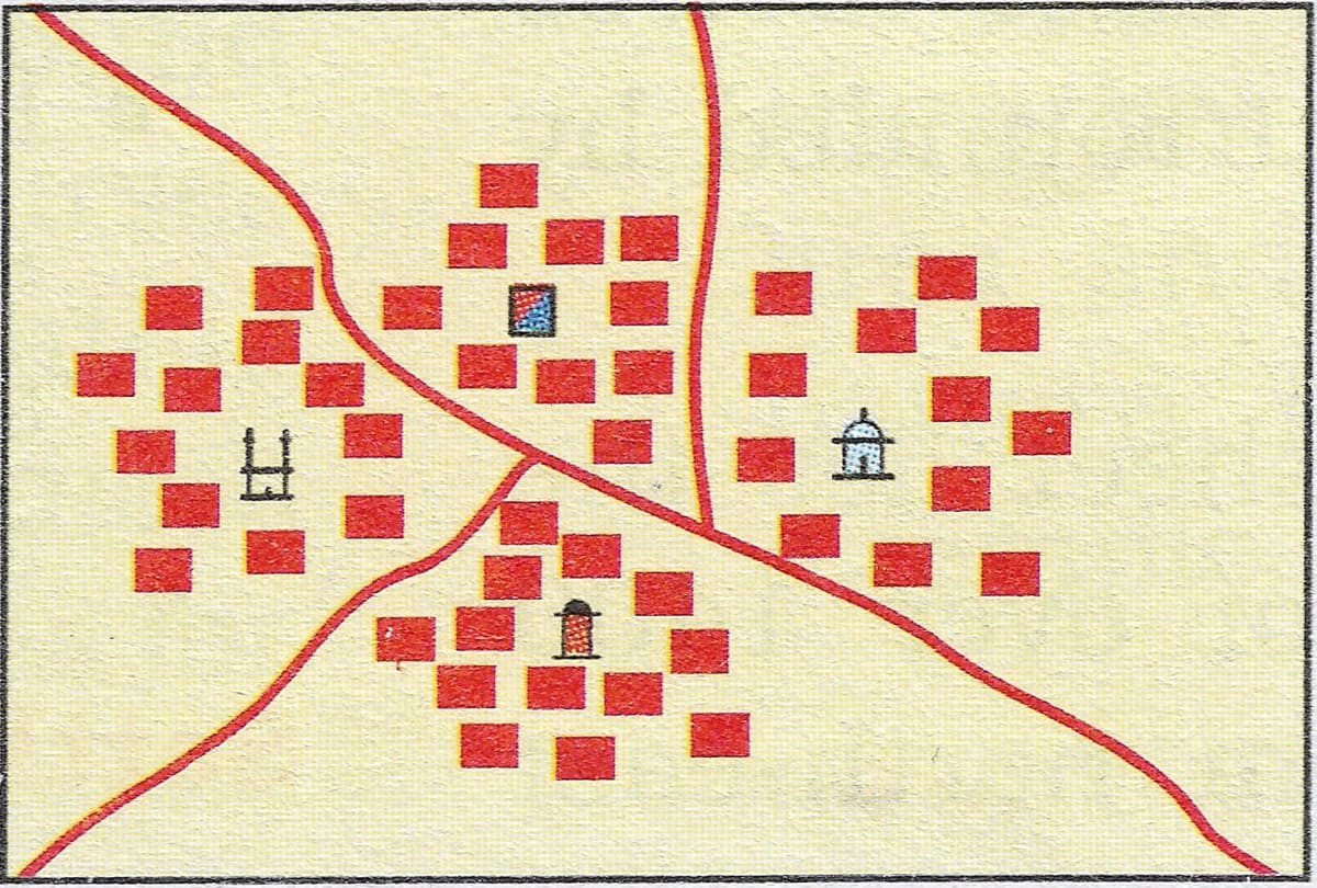
Question 1.
What does the following diagram indicates? Write short notes on the features as indicated by the diagram.

Answer.
The diagram shows a dispersed settlement. It is a pattern of rural settlement in which most of the population lives in farms, houses, and cottages scattered over a large area. This settlement is associated with regions of high land, poor soils, and an abundance of available sources of water. It is also associated with large farms and a sparse population.
Question 2.
What does the following diagram indicate? Write short notes on the features as indicated by the diagram.
Answer.
The diagram shows a nucleated settlement. It is a form of rural settlement in which farms and other buildings are clustered together, often around some central feature like a church or police chowki, etc. This pattern is encouraged by the need for defence, the availability of water supply at particular locations, and the development of modern means of transport.
This post is all about the solution of class 10 icse subject geography for chapter 4: Map Reading and Interpretation.